The Mighty 5 Road Trip – Utah’s National Parks

If you haven’t heard of the Mighty 5, it’s time you pay attention. Covering various regions of southern Utah, each national park offers an unparalleled journey through some of the most breathtaking landscapes on Earth.
Each park, from the towering red rock formations of Zion National Park to the otherworldly hoodoos of Bryce Canyon, presents a unique tapestry of natural wonders waiting to be explored. Delve into the narrow slot canyons of Capitol Reef, where the earth seems to open up in a display of geological artistry, or stand in awe of the expansive vistas of Canyonlands, where the Colorado River carved its mark through time. From the surreal arches of Arches National Park to the serene beauty of the slickrock landscapes in Canyonlands, Utah’s Mighty Five beckon adventurers to witness the raw power and sublime beauty of nature at its finest. Whether you seek solitude amidst towering sandstone cliffs or seek adventure along rugged hiking trails, Utah’s national parks offer an unforgettable experience that will leave a lasting imprint on your soul.
INSIDER TIP: Since you’ll be visiting at least 5 national parks on this trip you’ll want to purchase an America the Beautiful Annual Parks pass ($80 at the time of writing this). This will give you unlimited access to all the National Parks (including the Grand Canyon if you include it on your itinerary) and save you the cost of daily entrance fees (about $35 a day).

Go West, young man (…or woman)
Utah has been on my bucket list for a while. I wanted to go a few years back, but with all the travel restrictions during the Covid crisis I had to put that plan on pause. As soon as things eased up though, I got the wheels in motion to make my dream a reality.
Starting in Las Vegas made the most sense; not only are flights cheaper, but the relatively short distance from Las Vegas to Zion makes it an accessible and rewarding destination for a day trip or a longer adventure.
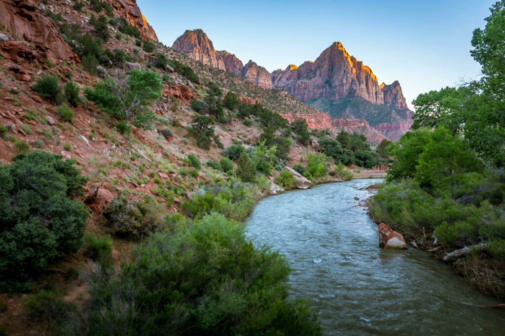
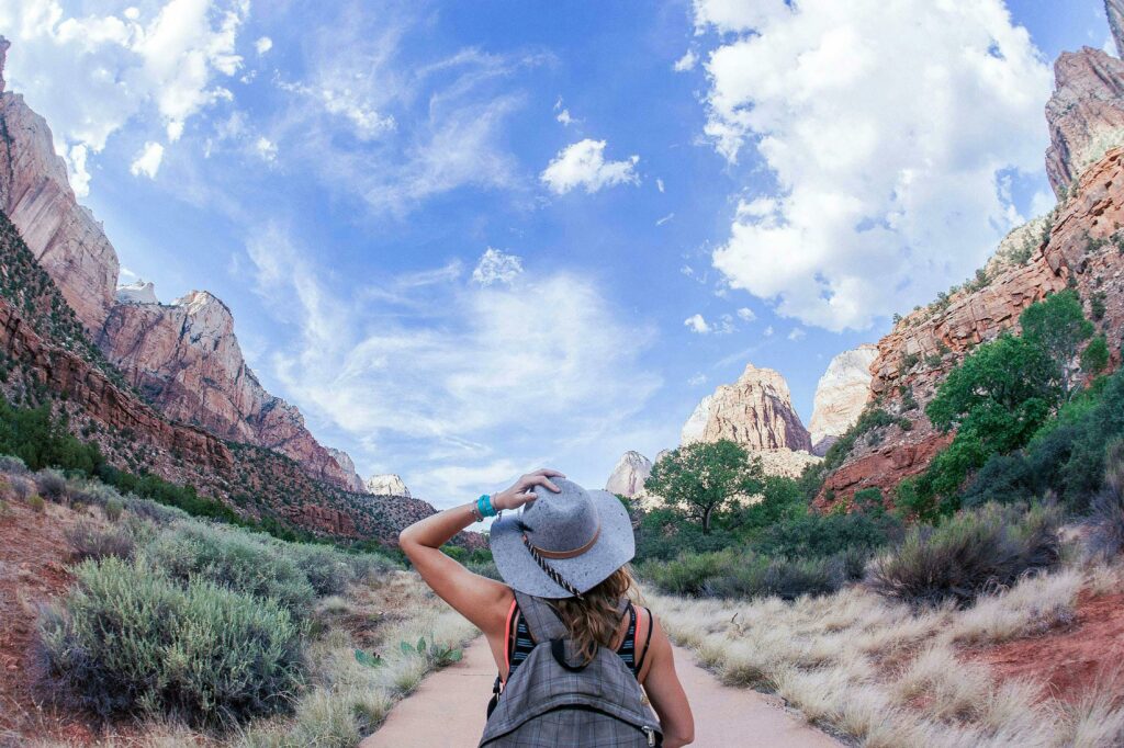
Zion National Park is one of the most stunning and visited national parks in the United States, renowned for its towering red cliffs, deep canyons, and the Virgin River that carves through the landscape. The park offers a variety of outdoor activities such as hiking, rock climbing, and wildlife viewing. The iconic hikes like Angel’s Landing and The Narrows provide unforgettable experiences amidst breathtaking scenery. Since Angel’s Landing requires a permit, we decided to hike as far as Scout Lookout before turning back. I did get to witness fellow hikers, though, continuing on to Angel’s Landing, where fearless hikers use chains to traverse the steep and narrow rock. The hike up to Scout Lookout is breathtaking and despite my fear of heights I was able to complete it.

As for The Narrows, I wanted to hike it (I had my neoprene socks and all), but it was closed due to high water levels. This is pretty common in the early spring (we visited early May), so plan your trip accordingly. Safety is the park’s top priority, especially in areas where flash flooding can occur. If you are planning to hike the Narrows, it’s a good idea to check the park’s website or contact them directly for updates on trail closures and conditions before your visit.Bryce Canyon – Not Really a Canyon at all!
Bryce Canyon – Not Really a Canyon at All!

From Zion we made our way to Bryce Canyon, which actually isn’t a canyon at all! Canyons are cut by a river, and unlike Zion or the Grand Canyon where the Virgin and Colorado rivers, respectively, run through them, Bryce doesn’t. Bryce Canyon is actually an “amphitheater” due to its unique geological formations called hoodoos. These tall, thin spires of rock create a stunning landscape that resembles the seating area of a theater. Over time, erosion from wind, water, and ice has sculpted the colorful limestone, creating this breathtaking natural amphitheater. It’s truly a remarkable sight to behold!
The elevation at Bryce reaches 9100 feet! Many people will experience something calling Mountain Sickness at these heights, where you can experience shortness of breath, dizziness and nausea, to name a few. It took me a couple days to adapt and most of my symptoms subsided, thankfully. Also at this elevation, expect cooler temperatures. When we arrived at Bryce there was still snow on the ground in some parts, and we needed a sweater or light jacket for early mornings or in the evening, so pack accordingly.
Bryce is great for non-hikers or those with mobility issues since there are so many lookouts throughout the park that offer killer views. BUT, for myself, I can’t go anywhere without a hike, so we opted to hike down into the amphitheater. There were a few sketchy parts, not for the faint-of-heart, but I think for the most part it’s a relatively easy hike for those in relatively good shape.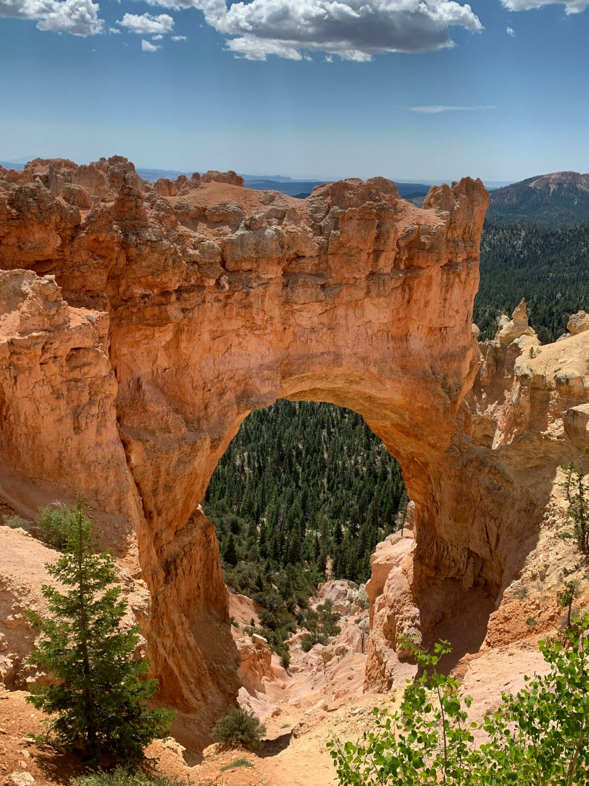
INSIDER TIP: Start the Navajo loop hike from Sunset Point and go counter-clockwise (connecting with Queen’s Garden). This way you’ve gotten most of the switchbacks out of the way and you’ll tackle them going downhill instead of up.
The Mossy Cave trail is another hidden gem in Bryce. It’s a short hike with a big payoff. Take the trail to the second bridge then go off trail and walk along the water until you reach Tropic Ditch Falls. You can walk right up to them from here and instead of viewing the falls from the top you’ll get a much better view from the bottom. It’s a nice early hike to do before heading towards Capitol Reef.
Capitol Reef National Park – Fresh Pie Anyone?!
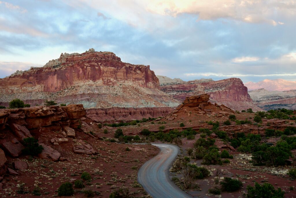
Continuing on our road trip we opted for the slower and more scenic route via Highway 12. Warning to my fellow Acrophobic friends: there are a few areas on this drive where you see nothing but steep cliffs next to you. My palms were definitely sweating and I had a death grip on the wheel at times, but we made it alive, and lived to tell the tale!
On a side note, I’m a huge fan of the Shaka Guide app (we used it all over Hawaii) and so when I saw they added Utah I made sure to purchase it in advance of our trip. It’s like having a personal tour guide in the car along with you, and offers great recommendations about where to stop, hike, eat, etc. Plus, a history of the area and that you wouldn’t get just driving alone without it. I highly recommend it!
We didn’t plan to do much in Capitol Reef since we had a long drive to Moab ahead of us and another 5 days of intense hiking, so we opted for a few scenic lookouts and a quick stop in the town of Fruita to visit the Gifford Homestead. Located within Capitol Reef National Park, the Gifford Homestead stands as a testament to the pioneering spirit of early settlers in the region. Built in the early 1900s by the Gifford family, this historic homestead offers visitors a glimpse into the past with its well-preserved buildings and artifacts. Surrounded by orchards and framed by the stunning red rock cliffs, the homestead transports visitors to a bygone era of self-sufficiency and perseverance. Today, visitors can explore the restored farmhouse, barn, and outbuildings, gaining insight into the challenges and triumphs of those who once called this rugged landscape home. Additionally, the Gifford Homestead offers homemade goods such as freshly baked pies (my purpose for going) and preserves, providing a taste of frontier life amidst the breathtaking beauty of Capitol Reef.
Upon our arrival around lunchtime, we found the Gifford Homestead closed for lunch. With only about 15 minutes until its reopening, I joined the growing queue, eager to sample their renowned pies. The wait proved worthwhile since the pies were delicious. I was relieved to learn that the homestead utilizes vegetable shortening in their crust, alleviating my concerns about lard. Opting for several varieties, including cherry, mixed berry, and peach, we savoured each bite. While cherry emerged as the favorite, the mixed berry filling offered the most delectable flavor, despite my slight aversion to its crumble crust; had it featured a traditional crust, it might have been the standout among the trio.
INSIDER TIP: The Homestead is typically opened from 9am-430pm, with a lunch break from 12-1, so time your visit accordingly so as not to be disappointed.
There aren’t many places to stop and eat along this route, so the pie ended up being a good filler until we could get real food in our bellies.
Arches & Canyonlands

Canyonlands and Arches National Park, both located near the town of Moab, offer unparalleled landscapes and outdoor adventures. Canyonlands boasts dramatic canyons carved by the Colorado River and its tributaries, creating a rugged and diverse terrain of towering mesas, spires, and arches. Visitors can explore its vast expanse through hiking, backpacking, four-wheel driving, and river rafting, immersing themselves in the raw beauty of this desert wilderness. Meanwhile, Arches National Park is famous for its more than 2,000 natural sandstone arches, including the iconic Delicate Arch (the one on the Utah license plate). The park’s surreal rock formations, including balanced rocks and towering fins, create a mesmerizing playground for photographers and outdoor enthusiasts alike. There are no shortages of hiking trails in this area, so it’s hard to narrow down which ones to tackle over a short trip.
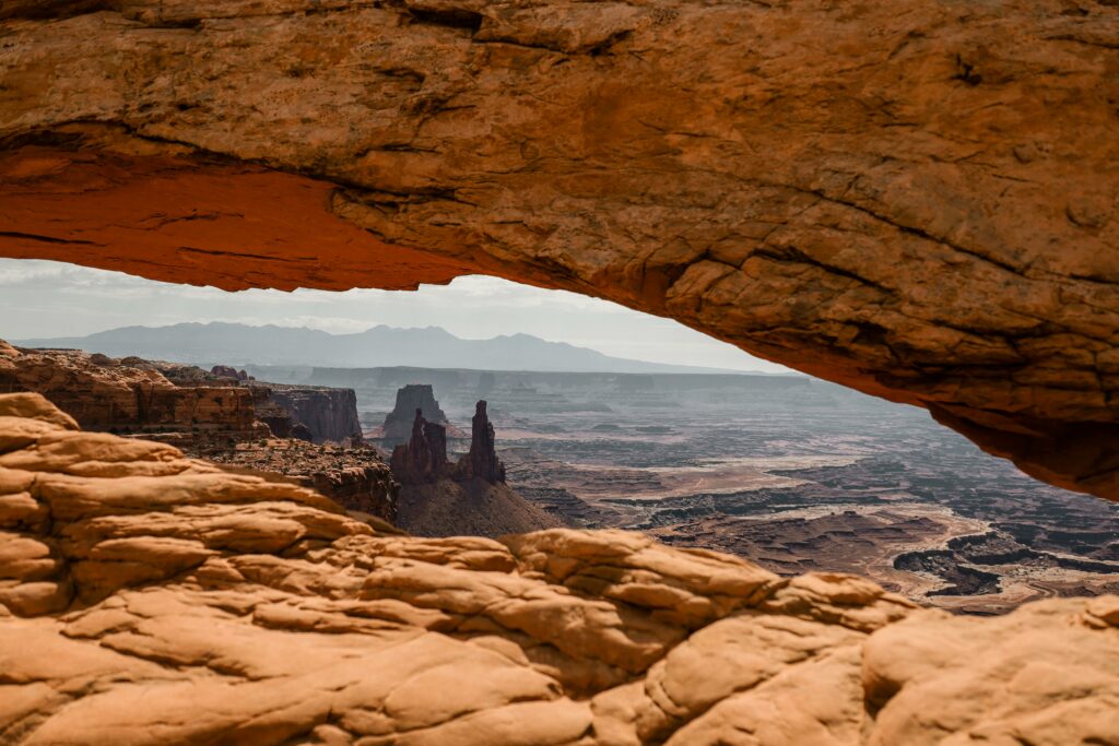
Canyonlands National Park is divided into four distinct districts, Island in the Sky, The Needles, The Maze and The Riverside district, each offering its own unique scenery and outdoor experiences. The Island in the Sky district is probably the most visited and easiest accessible. It’s characterized by its expansive mesa top views (Mesa arch pictured above), towering sandstone cliffs, and panoramic vistas of canyons carved by the Colorado and Green Rivers. Visitors can enjoy scenic drives along the park’s rim, as well as hiking trails that lead to overlooks and viewpoints. The mesa arch trail is a nice short hike (1/2 hour) with a stunning payout. If you want to visit for sunrise you’ll need to get there early to compete with the photographers. We arrived early morning and it was still quite crowded and it took a while to grab a crowd-less photo.
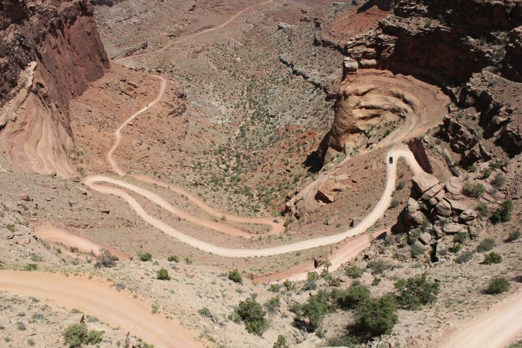
The Shafer Trail in Canyonlands is a rugged and iconic route that offers adventurer seekers a thrilling journey through the canyon. This unpaved road descends steep switchbacks from the Island in the Sky mesa to the canyon floor below, providing stunning panoramic views of the surrounding canyons, cliffs, and rock formations along the way. I was tempted to drive it, but my fear of heights got the best of me, and so I was perfectly content viewing it from the overlook.
The Needles district features a labyrinth of towering rock spires, narrow canyons, and ancient petroglyphs. Hikers and backpackers can explore a network of trails that wind through this rugged landscape, providing opportunities to discover hidden arches and towering rock formations. The Maze district, renowned for its remote and rugged terrain, offers a true wilderness experience for adventurous visitors. Accessible only by four-wheel-drive vehicles or on foot, this area boasts towering cliffs, slot canyons, and expansive vistas, providing a sense of isolation and solitude. Lastly, the riverside district, known as the Green and Colorado Rivers, offers opportunities for whitewater rafting, kayaking, and canoeing through stunning canyon scenery, providing a unique perspective on the park’s geological wonders. We kept our visit strictly to the Island of the Sky district for time’s sake.

Arches National Park, is a mesmerizing landscape of sandstone arches. These arches come in various shapes and sizes, from delicate and slender to massive and imposing, with the iconic Delicate Arch standing as a symbol of the park. Plenty of hiking trails offer visitors the opportunity to marvel at these natural wonders up close. Additionally, scenic drives provide access to panoramic viewpoints and overlooks, plus awe inspiring views of the La Sal mountains in the backdrop.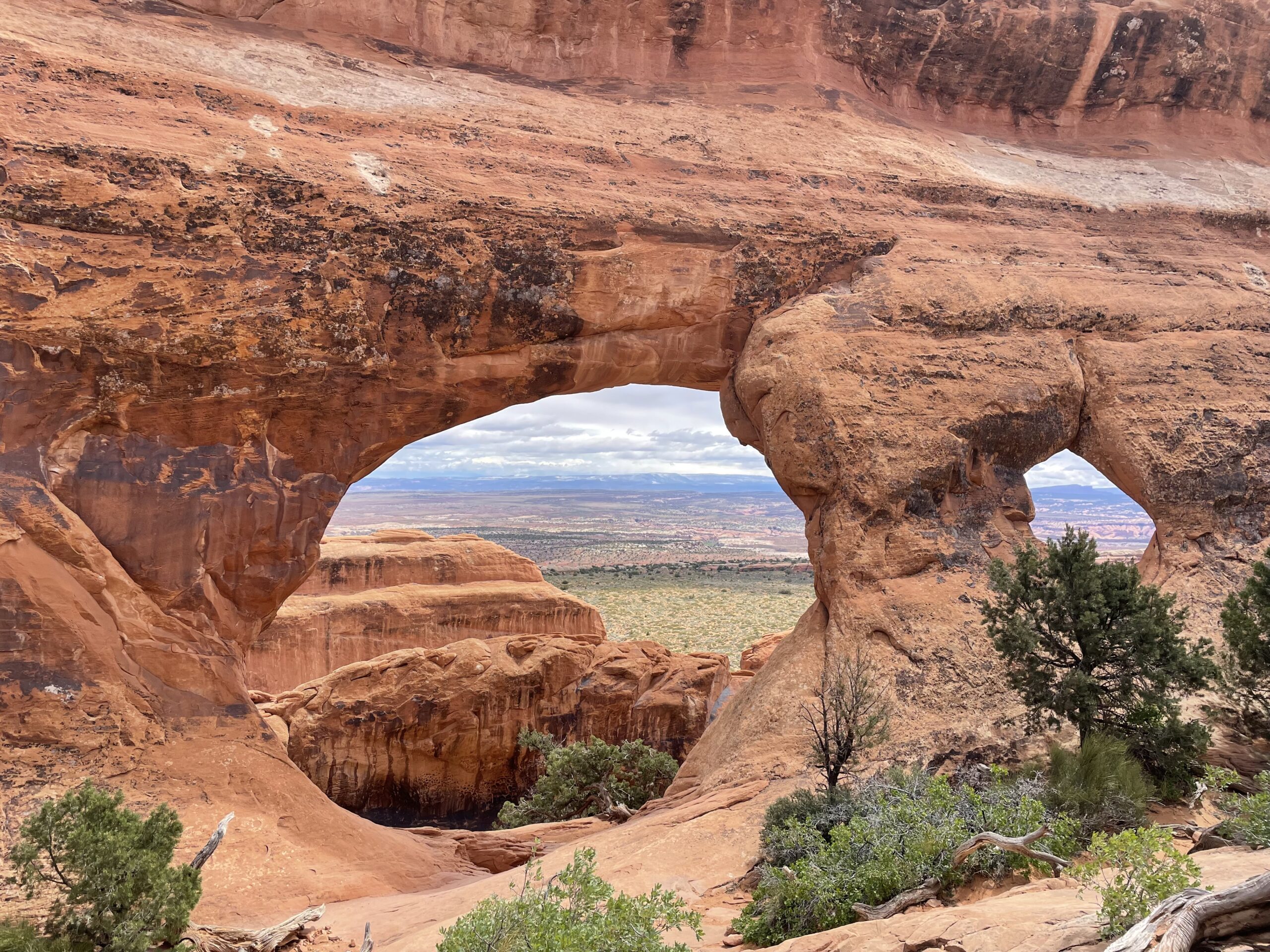
With so many arches to choose from, we settled on a few to hike to. The Devil’s Garden trail covers a handful of arches all along one route. Since there’s no shade along this trail I recommend hiking it early in the morning or late in the day. Pine, Landscape, Partition, Black and Double O are just some of the arches you’ll see along this route.
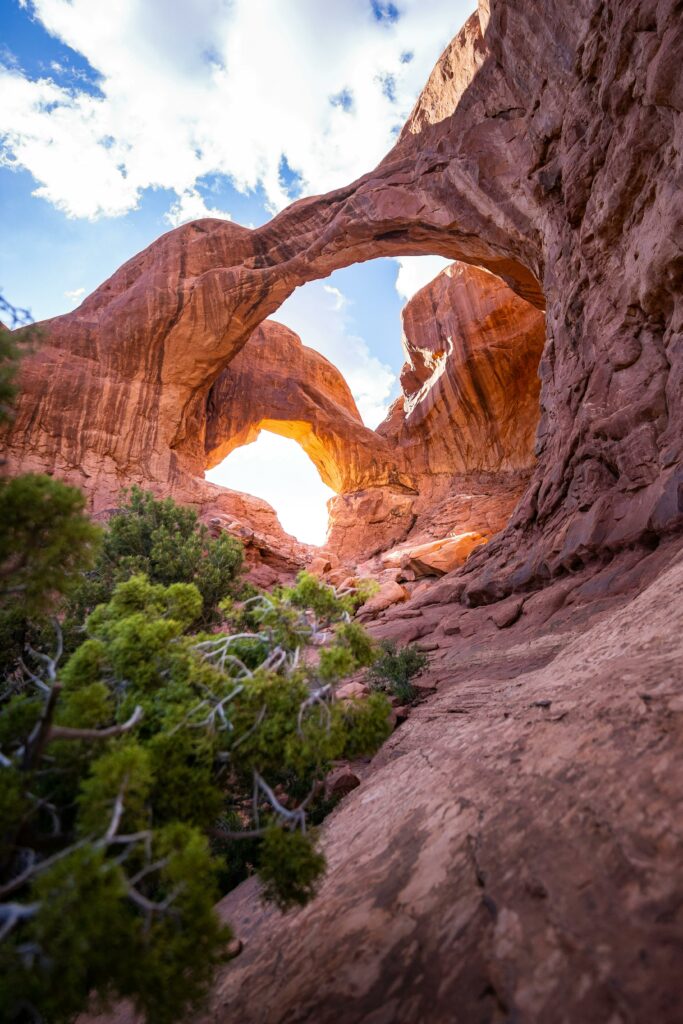
There are some narrow portions, rock scrambling and steep drop offs along this trail, so keep that in mind. Going down was definitely more terrifying, and there was a portion that I literally came down via my butt, but it was well worth the stunning views.
The town of Moab has numerous hotels, and numerous restaurant options, as well as, a couple of grocery stores where you can grab food, snacks or a light meal. We spent 4 nights in Moab, and that was still not even close to enough time to see everything. Crowds were still relatively high, so I can only imagine visiting here in the summer months. With only a few entrance stations, expect waits of half an hour or more at the National Parks (we saw lines of 1hr+ waits), so make sure to arrive at the park early or later in the day.
INSIDER TIP: Arches NP requires a timed entry ticket that you’ll reserve in advance (at a cost of $2). You must enter within the hour window you select at the time of your reservation, but after that time you can come and go as you please. Alternatively, there are no advanced reservations required before 7am or after 3pm, so if you missed getting a reservation, you’ll want to visit at those times.
Monument Valley, and Antelope Canyon AZ
From Moab we were headed to Page, Arizona for a couple nights to visit Antelope Canyon. I had read conflicting reviews online, with some saying it’s not worth the detour, but I’ve had plenty of clients go and love it, so I went ahead and included it in my itinerary.
The drive to Page from Moab is quite scenic. The early part of the drive still blesses the eyes with the La Sal mountains, and Wilson arch was quite impressive. There were a few stops I contemplated along the route; Monument Valley, Valley of the gods, and Goosenecks State Park. By ten days in though, my kids were mostly hiked out and the scenery was getting a bit repetitive.

We did stop make a photo stop though at the iconic Forrest Gump Point, made famous from the movie Forrest Gump. The road here provides an expansive view of Monument Valley, and you’ll find many others pulling off to take pics or standing in the middle of the road to get their photo taken.
If you have the time you might want to include Monument Valley as a part of your itinerary. Since it’s on Navajo land, there’s a separate park entrance fee that’s not covered in the National Parks pass. Alternatively, Valley of the gods road provides similar scenery at no cost but the detour will add a couple hours to an already lengthy drive.
We didn’t stop outside Monument Valley though to try some Navajo fry bread. The freshly fried (in olive oil!) dough is a staple in the Navajo diet. We had ours drizzled with honey and it was quite the treat. Again, since there aren’t many food options along the route, it was a satisfying snack to tide us over until we got to Page.

We did, however, make a stop at Goosenecks State Park. Often compared to Horseshoe Bend in Arizona, Goosenecks State Park, located in southeastern Utah near the town of Mexican Hat, offers one of the most stunning examples of entrenched river meanders in the world. The park overlooks the San Juan River as it winds its way through deep, narrow canyons, creating a series of tight, intricate loops known as goosenecks. From the park’s viewpoints, visitors can gaze down into the depths of the canyons, where the river carved its way through the desert landscape over millions of years. The view from the overlooks is truly awe-inspiring, with layers of colorful rock strata adding to the dramatic scenery. While the park is relatively undeveloped, it offers basic amenities such as picnic tables, restrooms, and primitive camping – the entrance fee is $10.
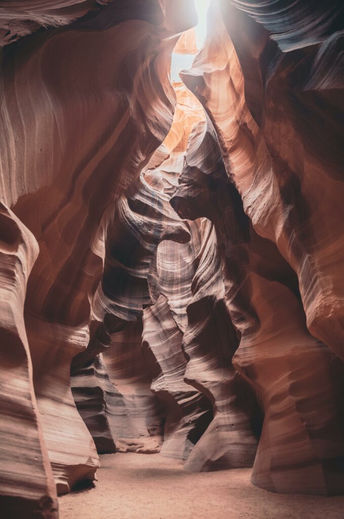
How One Photo Changed a Town
Next on the itinerary was Page, Arizona. Situated in the northern part of the state near the Utah border, is a picturesque town surrounded by some of the most stunning natural attractions in the American Southwest.
Page is home to the breathtaking Antelope Canyon, a slot canyon renowned for its mesmerizing light beams and swirling sandstone formations. Antelope Canyon is located on Navajo Nation land and access to Antelope Canyon is only through guided tours operated by Navajo guides, who provide insight into the canyon’s geology, history, and cultural significance. These tours help ensure the preservation of the canyon while allowing visitors to experience its stunning beauty and unique formations. The slot canyon, composed of sandstone, was formed by the erosion of Navajo Sandstone primarily due to flash flooding and wind. Visitors can explore both Upper and Lower Antelope Canyon, immersing themselves in the narrow passageways and sculpted walls that have been shaped by millennia of erosion.
We opted for a tour of the Lower Canyon with Dixie Ellis Tours. The Lower, we were told, is better for exploring. On the Upper, you’ll find more photographers trying to fight for a coveted spot to recreate that famous million dollar shot.

INSIDER TIP: Due to its popularity and unique geological formations, tours are extremely popular and can sell out months in advance, so book early not to be disappointed.
Social media has helped this town grow exponentially; now you’ll find almost every hotel chain here, and accommodations for every budget. One of the most expensive photos ever sold was taken in Upper Antelope Canyon. As sunlight filters through the narrow slot canyon openings, it creates breathtaking beams of light that dance across the smooth, undulating walls of the canyon. These light beams, often referred to as “shafts of light” or “sunbeams,” occur at certain times of the day when the angle of the sun aligns perfectly with the narrow openings and the canyon’s geometry. Now people flock here to try and recreate that iconic shot.
Capturing the elusive light beams within Antelope Canyon requires precise timing and patience, as they can vary in intensity and direction depending on the time of day and weather conditions. Photographers often visit during the mid-morning or mid-afternoon hours when the sunlight is at its most dramatic, casting striking contrasts of light and shadow against the canyon walls. The result is a series of breathtaking photographs that showcase the canyon’s ethereal beauty and the magical interplay of sand and light.
In addition to these natural wonders, Page offers a range of outdoor activities such as hiking, mountain biking, and off-roading in the surrounding desert landscape. The town itself provides amenities including hotels, restaurants, and shops catering to travelers exploring the region’s attractions. With its proximity to so many iconic landmarks, Page serves as an ideal base for adventurers looking to experience the unparalleled beauty of northern Arizona.
From here we decide to take the quick route back to Las Vegas, alternatively though, you can head south and visit the Grand Canyon from here. Since we’ve already been on a past trip we skipped it, but I highly recommend going that route for anyone who has never been.
Las Vegas – The City of Neon Lights

Las Vegas offers a unique experience filled with endless entertainment, world-class dining at celebrity chef restaurants, and iconic attractions. As you approach the glittering cityscape, the famous Las Vegas Strip emerges, lined with extravagant hotels, casinos, and dazzling neon lights. From the opulent resorts like the Bellagio and the Venetian to the iconic landmarks such as the High Roller observation wheel and the Fountains of Bellagio, there’s no shortage of spectacles to behold. For this nature lover, though, Las Vegas is nothing more than an icon for superficiality, due to its emphasis on excess; It’s not called Sin City for nothing.

Nature lovers will find plenty to discover and enjoy just beyond the neon lights. Beyond the glitz and glamour of the Strip lies a surprising array of natural wonders waiting to be explored.
Just a short drive away from the city, visitors can escape to the tranquility of Red Rock Canyon National Conservation Area, where towering red sandstone cliffs, scenic trails, and desert wildlife await. Alternatively, Lake Mead National Recreation Area offers opportunities for boating, fishing, and hiking amidst stunning desert landscapes and the shimmering waters of Lake Mead.
For those seeking a more immersive outdoor experience, nearby destinations, such as Valley of Fire State Park and Mt. Charleston, provide opportunities for hiking, camping, and wildlife viewing.
Valley of Fire has an entrance fee of about $15 but it’s worth every penny. Elephant Rock is a great place to catch the sunrise and the Fire Wave is a nice easy hike if you’re short on time. This moderate trail, approximately 1.5 miles round trip, leads visitors to a breathtaking natural wonder known as the Fire Wave—a unique sandstone formation that resembles rippling waves of fiery red and orange hues. Go early though if you’re there in the summer months. It gets very hot, and there’s no shelter from the sun!